• enEnglish
    • elΕλληνικα (Greek)
  • Shortcuts
    • International Relations Office (IRO)
    • Time Schedule
    • Library & Information Centre
    • Phonebook (in greek)
PRD-UThPRD-UThPRD-UThPRD-UTh
Department of Planning and Regional Development
School of Engineering
University of Thessaly
  • Home
  • The Department
    • The Department and its Location
    • The Department in the Local and Academic Community
    • Administrative Structure
    • Opinions of Graduates
    • Establishments
  • Studies
    • Undergraduate Programme
      • Presentation
      • Courses
      • Time Schedule
    • Graduate Programs
      • Master in Urban Regeneration, Urban Development & Real Estate [URUDRE]
        • Courses
      • Master in Sustainable Management of Environmental Change and Cyclical Economy [SMECCE]
        • Courses
      • Master in Project Management, Transportation and Spatial Planning (PMTSP)
        • Courses
      • Master in Tourism and Cultural Planning and Development (TCPD)
        • Courses
      • Masters in Strategic Management and Competitiveness (SMC)
        • Presentation (in greek)
    • Doctoral Studies
    • Postdoctoral Research
  • Research
    • Scientific editions
      • Research – Discussions Papers
      • e-journal “Aeihoros”
      • Institutional Repository
    • Research Units
      • Research Unit of Computer Science Applications in Spatial Planning
      • Research Unit of Demographic and Social Analysis
      • Research Unit of Evaluation of Development Policies and Programs
      • Research Unit of Environment and Spatial Planning [ESPL]
      • Research Unit of Geographical Research and Environmental Planning [GREENPLAN]
      • Research Unit of Infrastructure, Technology Policy and Development [RUITPOD]
      • Research Unit of Regional Economic Analysis and Policy
      • Research Unit of Rural Space
      • Research Unit of Spatial Analysis, GIS and Thematic Mapping
      • Research Unit of Tourism Planning, Research and Policy
      • Research Unit of Urban Space Morphology
      • Research Unit of Urban and Spatial Planning
    • Research Centers
      • Informations System Center
  • Staff
    • Faculty Members
    • Research and Technical staff
    • Other Faculty
    • Adjunct Faculty
    • Administrative Staff
  • Support
    • Secretary
    • International Relations Office (IRO-UTH)
    • Library & Information Centre
  • Contact

Research – Unit of Rural Space

Profile

The Laboratory of Rural Space covers educational and research needs in the fields of rural development and planning, emphasizing:
  • the formulation of integrated local development and territorial strategies in rural areas at every scale (community, municipality, intermunicipality, ),
  • the evolution of the territorial development model, focusing:
    • On the methods of identification, emergence and enhancement of local territorial resources through adapted action plans of an integrated nature which incorporate the local social capital and the diaspora,
    • on the improvement of the role of local actors in the participatory process of preparing a development plan, from diagnosis, to the formulation of actions and their application plan (operational planning),
    • on the organisation of territorial governance and active participation in the planning and application of territorial public action (bottom – up planning of multi-sectoral and multi-funded programs)
  • the development of small towns in rural areas and their role in local government
  • the evolution of family farming
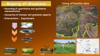
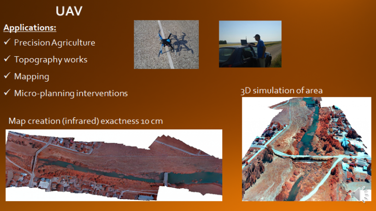
  • the contribution of new technologies (geo-informatics science) in the creation of spatial analysis tools, territorial diagnosis and the construction of specific territorial resources

Representation of the National Strategy of the Troodos Mountain Communities (Nicosia, June 2018)


Master of Science «Territorial Dynamics and Spatial Planning », DYNTAR:

The research team of the Laboratory of Rural Areas supports since 2004 the function and organisation of the common Greek-France MSc DYNTAR based in Volos, which is annual. The official language teaching is French. MSc DYNTAR provides knowledge in scientists of different topics and specialities in issues that are connected with the territorial organisation and the development of rural areas.

The scientific laboratory team contributes to carry out a collective project in the context of Master DYNTAR which each year focuses on a developmental issue in Thessaly (Skopelos, Elassona, Farkadona, Almyros, Mouzaki Sofades, …)


Activity

Research Activities (in brief):

The main research activity of the Laboratory is organised around the needs of the Strategical and Operational Planning of Development and Territorial Interventions in rural areas. These activities are analysed on two basic axes concerning a) the formulation of adapted and appropriate methods and techniques for analysing and processing the investigated events (diagnostic) and b) the thematic focus on specific events that contribute decisively to the development and the evolution of rural areas

On a methodological level:

  1. Organization of localdiagnosis with the active participation of local actors
  2. Development of methodology for the identification, emergence, and enhancement of territorial resources
  3. Development techniques to support the participatory process (local consultations).
  4. Development of specialised technological tools (using the science of geo-informatics, (satellite images, remote sensing, GIS, 3D applications, etc) which combines spatial information with the participation of local actors.
  5. Analysis of spatial systems for the rural area.
  6. Analysis of productive systems and identification / enhancement of territorial ties to the territory
  7. Processing and analysis of satellite images – Aerial photography
  8. Digital interactive cartographic representation of spatial  phenomena


On a thematical level:

  1. Territorial development method, Construction of territorial areas: territorial resources, cooperation / coordination of local actors
  2. New rural economy/cross-sectoral horizontal and vertical relationships within territorial areas
  3. Family farming and sustainable production systems with ties/links to their areas/regions
  4. Agro-environmental management
  5. Territorial governance (local government, local actors, expatriates etc.). Company forms and networks (organisation of collective interventions at the local level)
  6. Structures andsupport mechanisms
  7. Planning population reception policies in rural areas
  8. organization of business chains and clusters for local goods and services
  9. Investigation of theforms of valorization of the Social EconomyandEntrepreneurship
  10. organisational framework for awarding quality labels to areas and products (criteria and processes)

Research

Research Projects (titles):  

2020: Olympus products revelation and Guarantee Participation System implementation

2018-2019: Alternative food networks and territorial marking. The Role of Consumers in improving the Recognition and Efficiency of Participatory Certification Systems, GGET, EDBM-34: Research Support with Emphasis on Young Researchers

2017-2019: National Strategy for the Development of Troodos Mountain Communities, Cyprus, financed by Foundation Giannakis Papadouris for the Cyprus Republique

2016-2019: «HNV-Link: High Nature Value Farming: Learning, Innovation and Knowledge (Grant Agreement No 696391)», European programme HORIZON 2020,

2016: Research for “Development of Livestock in the Mountainous Area of Farkadona Municipality: Prospects for Reconstruction and Development” Development Agency of Trikala -KENAKAP SA

2014-2016: Pilot improvement of pastures at Sofades’ Municipality and Mouzaki’ Municipality

2014-2015: «Routes and Heritage of the Nomadic World Heritage Site» Expertise financed by the Leader Program (transnational cooperation) KENAKAP SA

2013-2014: “Employment Local Plans”, financed by Development Association of Northern Sporades Development Association of Almyros and Development Association of Thessalia and Action

2012-2015: “LACTIMED- promotion plan Mediterranean dairy products”, UE, strategic european program ENPI CBC MED

2012-2013: “Geo imaging of the archaeological site of Azoros, Elassonas’ Municipality (area of about 10 stremmas) and implementation of archaeological research with combination of innovative geophysical methods and tools GPR”. Financed by Ellasonas Municipality

2012-2014: “Local actions for social inclusion for vulnerable groups” financed by Development Association “network COOPERATION”

2011-2013: “Provision of consulting technical and scientific support for the project “ENERSCAPES – TERRITORY, LANDSCAPE AND RENEWABLE ENERGIES””, financed by Thessaly Region, program MED

2011-2012: “NOVAGRIMED – Agricultural innovations in the Mediterranean”, financed by Thessaly Region, program MED

2008: “National Study of Agricultural and Rural Development in the context of monitoring the Mediterranean Strategy for the Sustainable Development”, financed by PLAN BLEU, Mediterranean Committee on Sustainable Development (MCSD)

2007-2009: “Emergence of local territories in the Mediterranean area. Comparative analysis within third countries of Magreb, France and 6 countries from South, North and East)”, financed by MSH/ fsp Maghreb

2007: Scientific and technical support for the spatial and socio-economic analysis of Municipality of Kleinovos (SCHOOAP), Koutakos Christos-Planner

2006 – 2011: Operational and Development Programs for Municipalities and Regions (Othrys’ Area, Almyros Municipality, Troodos Area (Cypre), Marathasa Area (Cypre), Farkadona Municipality, Nessonos Municipality) financed by them

2006: “Strategic plan for re-constructuring and development of the agriculture of Peria’s Region”, financed by Department of Pieria

2005-2008: “Social-Solidarity Economy and Entrepreneurship -Local Society – Integrated Support”, financed by Initiative Equal

2004-2008: French-Meditarranean program. «Mondialisation et construction des territoires ruraux en Méditerranée». Coordinateur : Omar BESSAOUD. Comparative analysis between the three countries of Maghreb, France and 7 more Mediterranean countries.

2004:  European Program TEMPUS (FORMDER: «Formation multipole et pluridisciplinaire en développement rural». Participation of France, Morocco, Egypt and Greece. Scientific responsible for Greece.

2004: “Study of identification and emergence of social economy actions in the field of the realization of Regional Operating Program according to the Thessalian specificities”, financed by Thessaly Region

2003-2006: Local Initiative for the Employment in the Tyrnavos’ area and in Almyros’area, Rural Space Laboratory participates in the partnership (Operational Regional Program of Thessaly)

2003: Management Authority LEADER+, Ministry of Agriculture. «Expert report for the Plan of Action for the Participation of Greece in the European Program “LEADER Mediterranean”».

2003:  General Secretariat of the Region of Thessaly. «Study on the development of the plane of Thessaly»

2003: European Program «Leader-meda», responsible for the project realization and for the zones and Local Action Groups selection that will participate in the Program from Greece.

2003: Promoting real convergence in the regions of Epirus, Thessaly, Western Macedonia and the Peloponnese”, expertise financed by: Ministry of Economy and Finance of Greece

2002-2004: “Promoting Network for Employment”, financed by Initiative Equal -Network for the promotion of employment” of the Equal Community initiative, especially in the actions: i) “Exploiting & upgrading of existant researchs and studies, in order to preview the dynamics of the business and production systems”, ii) “Development of new skills, new qualifications and new jobs” and iii) “Coordination and monitoring – Control – Certification – Assessment” financed by Ministry of Employment and Social Assurances. awarding body Hellenique Society of Development and Local Authorities- Scientific responsible

2002-2003: European Program ALTENER. «Alternative Crops Integration in a Spatial Analysis», in collaboration with CIEMAT, INRA and AUA.

2002: «Intergrated Program for the Development of the Rural Area of Othrys in the Prefecture of Magnesia», appointing organization Region of Thessaly/Magnesia Development Agency. Scientific responsible.

2001-2002: «Les institutions et les organisations du développement rural en Méditerranée», awarding body : Network CIHEAM-RAFAC. Implementing body: University of Thessaly- Rural Space Laboratory. Scientific responsible.

2000-2001: Program of Developmental Aid Ministry of Environment, Planning and Public Works, (DAC/OECD). “Management of Man-made and Natural Environment in the mountainous south-west section of the Koritsa-Albania region”. Implementing organization by: University of Thessaly, Laboratory of Rural Area. Scientific responsible.

Outcomes

Research results/ products :  

  1. pilot project of spatio-temporal pasture management- implementation area : AnavraMagnesia
  2. Register ofsocial economy associations at national (1999) and Thessaly’s Region (2008)
  3. Tool for the multi-criteria analysis in GIS environment for the installation of energy plants producing bio-fuel (program ALTENER)
  4. Methodological guides for the evaluation of local economical systems (Community Initiative Equal- circle A
  5. specialized tools, guides, methods in topics about the enhancement and promoting social economy and entrepreneurial (Community Initiative Equal- b circle)
    • Participation of Development Association KENTAVROS (Laboratory of Rural Territory was the coordinator and the main partner) in the committees of the Ministry of Employment for for creating the first legal framework for the development of social economy and entrepreneurship (L 4019/2011)
  6. Educationalmaterial (notesandvideotapedteaching in French) postgraduate level(transnational project TEMPUS)
  7. Contribution in the creation of the Local Quality Agreement «THRONOS» in Pieria
  8. Method of determiningspatialregulationsof the relationship between RES andLandscapein Municipalitiesandcorresponding action plan
    • acceptance andintegrationof the proposed strategyto regulate therelationshipRES andLandscapeofthe Municipal Council of Almyros
  9. Agreement of cooperation (Charte) of the actors which participated for developing a territory with the participation of local actors –associations and the diaspora, the community – municipallity, the Local Development Agencies the universities and research institutions (p.ex. University of Thessaly)
    • RecommendationSocial FundinEllinopyrgosto supportnewbusiness initiatives-Diasporawho want toreturn to the community-area
    • Expression of interest fromdiaspora to returnand install in the region asa resultof the Laboratory’s Initiative: “We build together the countryside”
  10. Application Guide for vertical integration of the production process in small producers’s teams (eg aromatic plants)
  11. Creation support unit for the energy plantsinstallation and the installation ofapproximately20 hectares  ofthistlesin the firstpilotyear of production
  12. Action plan for promoting of the consummation of local Mediterranean products though foodservice points (eg. schools, hospitals etc)
  13. Unit of identification and emergencing of natural and anthropo-centrical resources in countryside using the geo-information
    • Identification archaeological spots in the areas of Peukakia Volou, Skotoysa Farsala and Azoros Elassonas using the geo informatics from the unit of
  14. Organization and coordination of meetings, conferences and focused scientific groups with the participation of international level experts in the research topics of the laboratory.
  15. Scientific papers in international journals and books.

Services

Services to third parties (in brief)

Categories of Services provided:

  • Preparation of Operational Programmes to cover the needs of state actors, Regions and Municipalities-Communities as well as other local social and professional bodies, while supporting the implementation and monitoring of actions
  • Preparation of Specialised Action Plans to implement small-scale development interventions with the organisation of implementation steps accompanied by an application guide
  • Preparation of pilot studies and research on rural development issues such as tourism development, the organisation of tourism-cultural products, the development of agricultural innovation, and the organisation and promotion of agricultural supply chains
  • Preparation of spatial organisation plans at the regional and local level, which refer to land uses, spatial regulations and territorial- spatial specialization of development programmes
  • Formulation, application and management of European Programmes at the Municipal level (such as LEADER, MED programmes etc.)
  • Development of actions for the organization, animation and coordination of local and regional networks of a thematic and spatial nature, with the participation of local actors, government agencies, experts, entrepreneurs etc.
  • Technical and scientific support of the actors, farmers and bodies with initiatives that focus on increasing added value through specificity e.g. « Cultivate my fuel » in order to harness territorial resources :
    • Conversion of typical agricultural products into specific agricultural products with a geographical reference
    • Support of expatriates in the development of business activities in their place of origin
    • Inclusion of expatriates in the planning and management of development actions in their place of origin
  • Display of spatial data in an interactive area representation tool (Community-Municipality scale) for continuous use and update by the respective territorial management bodies as a tool for spatial documentation, spatial planning, consultations, decision-making and general planning
  • Comprehensive soil mapping to identify and map natural and man-made resources (archaeological monuments, underground networks etc.)
  • Provides pecialised training customised to the needs of actors and bodies, with the use of the following methods and tools,  to support the services provided
    • Diagnosis of the space, sectors and branches of the local and regional economy through the combination of social methods and new technical and technological tools in order to ensure the active participation and interactivity of the bodies and people involved
    • Dedicated methodology for the identification, emergence and enhancement of territorial and specific resources
    • 3D spatial representation tool (relief, infrastructure, hydrographic network, land uses, resources etc.) with fly-over function which is incorporated as an interactive tool in consultations, managerial decision-making, the adoption of quality standards, spatial planning etc.
  • Combined dynamic method using qualitative geoinformatics methods and tools (satellite remote sensing, GIS, ground penetrating radar for geophysical surveying, etc.) to map and identify: natural /man-made resources, archaeological monuments, underground networks etc.

Partners

Participation in Networks:

The Laboratory of Rural Areas participates in international scientific networks with topics such as planning and regional development especially the Mediterranean areas. The most important are the following:

PARM (2012-) Mediterranean think-tank with participation of the most important experts from 15 Mediterranean countries. Main task: Analysis and evaluation of the situation and the perspectives of the Mediterranean area and the elaboration of the proposals for the development of the Mediterranean region in collaboration with international organisations and the EU.

RAFAC (1994- ): realises comparative studies for the family farming and the rural development of the Mediterranean area sponsored by CIHEAM and the collaboration of academical and research organizations from all around Mediterranean. Prof. Goussios Participation since 1993, as a responsible for Greece in the focus groups: a. rural development, b. rural structures and politics, c. academicals educational applications,


Meeting of RAFAC Network (Greece, Volos 2008)

Groupe de Bruges. (1996-) Participation in the European scientific working group on “Agricultural and Spatial Planning Policies in the Rural Area”. Responsible : Edgar PISANI, former EEC Commissioner, B. Hervieu Under the auspices of DATAR and the European Union.

European University Network (2009- ) for the development of a methodology for evaluation of rural territories in order to achieve the European mark of quality,

Mediterranean Network for the patrimonialization of the pastoral culture sponsored by of UNESCO (2009), which is coordinated by the CHIEAM (International Centre of Higher Mediterranean Agronomic Studies). In the Network participating researchers and institutions related to livestock farming, especially the Transhumance to be recognized as a cultural and natural heritage under the Convention World Heritage of UNESCO http://resopasto.iamm.fr,

Experts network PLAN BLEU: 21 Mediterranean countries participated in the elaboration of a prototype system of regional environmental cooperation in the framework of the Action Plan for the Mediterranean Program of the United Nations for the Environment. The Network Plan Bleu is responsible for a) the production of information and knowledge relating to the environmental risks and challenges of sustainable development in the Mediterranean in order to alert the policy-makers, b) determination of strategies which facilitate the decision making. The Laboratory of rural areas involved in monitoring the implementation of the Mediterranean Strategy for Sustainable Development in subjects connected with agriculture and rural development. http://www.planbleu.org/

Founding Membre of the Euro-Mediterranean Think tank PARME (Prospective, Analyse et recherche de la Méditerranée) from 2013. Vice President from 2014.

Foncimed –Network of Research and Exchange on Mediterranean Land Issues

Réseau européen des zones de montagne (méthode commune de developpement durable). Coordination.


Research and Educational Cooperation with European Universities and Institutions

Based on the methodological and technological tools it has developed, the Rural Space Laboratory supports

2016-2018: the training of researchers of University of Tirana

2012+ : PhD candidates, and postgraduate students to prepare their thesis / postgraduate thesis coming from:

  • AgroParisTech, Institut des Sciences et Industries du Vivant et de l’Environnement, Paris France
  • Université de Montpellier III, Montpellier- France
  • Université Clermont –Auvergne (Blaise-Pascal), Clermont-Ferrand – France
  • Université de Lyon 2, Lyon- France
  • Université de Science and Technology Houari Boumediene, Department of Geography and Spatial Planning BAB EZZOUAR ALGER Algeria

2014+: undergraduate students in the preparation of graduate thesis and other forms of practical applications coming from:

  • Université Maine, Mans- France
  • Université de Tours, Tours – France
  • Université de Lyon 2, Lyon – France

Equipment

  1. Four Desktops PC and Three Laptops. The latest of them have capabilities in image processing
  2. Three network printers: HP laser professional Α4, HP inkjet color Α4, HP color Inkjet A3
  3. One Video projector
  4. Two Drones for mapping: IRIS-3Drobotics & Matrice100 – DJI
  5. High precision GPS RTK receiver. It is capable of supporting multiple satellite constellations: GPS, GLONASS, BEIDOU and GALILEO.
  6. Two 360 cameras.  Real 360° 4K VR Camera
  7. Virtual Reality glasses for smartphone applications
  8. Special software for: (α) spatial data analysis: satellite images, aerial photography, spatial-data, 3D interactive represantations:  Agisoft-Photoscan, Erdas Imagine  & (β) statistical data analysis: SPSS, excel

Use and results of special equipment in Laboratory of Rural Space

http://www.dyntar.prd.uth.gr/

rurlab@prd.uth.gr

tel: 24210  7 4463

fax: 24210 7 43

Β13, Building PRD-UTh

Staff

Director

Members

Past Academic Staff

Dimitrios Goussios

Other Faculty Members

Theodosia Anthopoulou

Laboratory Teaching Staff (EDIP)

Dimitra Gaki

Prodromos Mardakis

Laboratory teaching staff from other department

Ioannis Faraslis

Additional Postgraduate Academic Staff

Stylianos Kouzeleas

Nikolaos Poutsiakas

Research Associate

Apostolos Goulas

Konstantinos Tsimpoukas

Supporting

Contact info


Pedion Areos, 383 34, Volos

+30 24210 74452-55

+30 24210 74380

g-prd@prd.uth.gr

News

  • Events
  • Academic
  • Administrative

ΣΥΝΔΕΣΜΟΙ

  • The Department
    • The Department and its Location
    • Administrative Structure
    • The Department in the Local and Academic Community
© Τμήμα Μηχανικών Χωροταξίας, Πολεοδομίας και Περιφερειακής Ανάπτυξης | Πολυτεχνική Σχολή | Πανεπιστήμιο Θεσσαλίας
  • Home
  • The Department
    • The Department and its Location
    • The Department in the Local and Academic Community
    • Administrative Structure
    • Opinions of Graduates
    • Establishments
  • Studies
    • Undergraduate Programme
      • Presentation
      • Courses
      • Time Schedule
    • Graduate Programs
      • Master in Urban Regeneration, Urban Development & Real Estate [URUDRE]
        • Courses
      • Master in Sustainable Management of Environmental Change and Cyclical Economy [SMECCE]
        • Courses
      • Master in Project Management, Transportation and Spatial Planning (PMTSP)
        • Courses
      • Master in Tourism and Cultural Planning and Development (TCPD)
        • Courses
      • Masters in Strategic Management and Competitiveness (SMC)
        • Presentation (in greek)
    • Doctoral Studies
    • Postdoctoral Research
  • Research
    • Scientific editions
      • Research – Discussions Papers
      • e-journal “Aeihoros”
      • Institutional Repository
    • Research Units
      • Research Unit of Computer Science Applications in Spatial Planning
      • Research Unit of Demographic and Social Analysis
      • Research Unit of Evaluation of Development Policies and Programs
      • Research Unit of Environment and Spatial Planning [ESPL]
      • Research Unit of Geographical Research and Environmental Planning [GREENPLAN]
      • Research Unit of Infrastructure, Technology Policy and Development [RUITPOD]
      • Research Unit of Regional Economic Analysis and Policy
      • Research Unit of Rural Space
      • Research Unit of Spatial Analysis, GIS and Thematic Mapping
      • Research Unit of Tourism Planning, Research and Policy
      • Research Unit of Urban Space Morphology
      • Research Unit of Urban and Spatial Planning
    • Research Centers
      • Informations System Center
  • Staff
    • Faculty Members
    • Research and Technical staff
    • Other Faculty
    • Adjunct Faculty
    • Administrative Staff
  • Support
    • Secretary
    • International Relations Office (IRO-UTH)
    • Library & Information Centre
  • Contact
  • enEnglish
    • elΕλληνικα (Greek)
PRD-UTh